
January 10, 2025
Summary
Over the past several months, most BSEC research theme teams have focused on data analysis and model evaluation related to summer data collection. This has included substantial studies of the air pollution, extreme heat, and vegetation datasets collected in collaboration with Equitable Pathways Steering Committee (EPSC) members and other community organizations. Much of this analysis is still in progress, and a results-oriented update will be provided at the next EPSC meeting. For this installment of the theme update, we highlight activities and progress of a few themes because of their relevance to EPSC interests. Of particular note is the initiation of the CoURAGE field campaign, which we can discuss in more detail at the EPSC meeting.
Select Theme Highlights
Atmospheric Dynamics
Draft manuscript on community-based weather station network: If you are hosting a station or coordinated deployment then you should have received an email linking to the draft manuscript. The goal is to submit this to the Community Science Journal to describe the collaborative effort to improve neighborhood-scale weather monitoring across Baltimore.
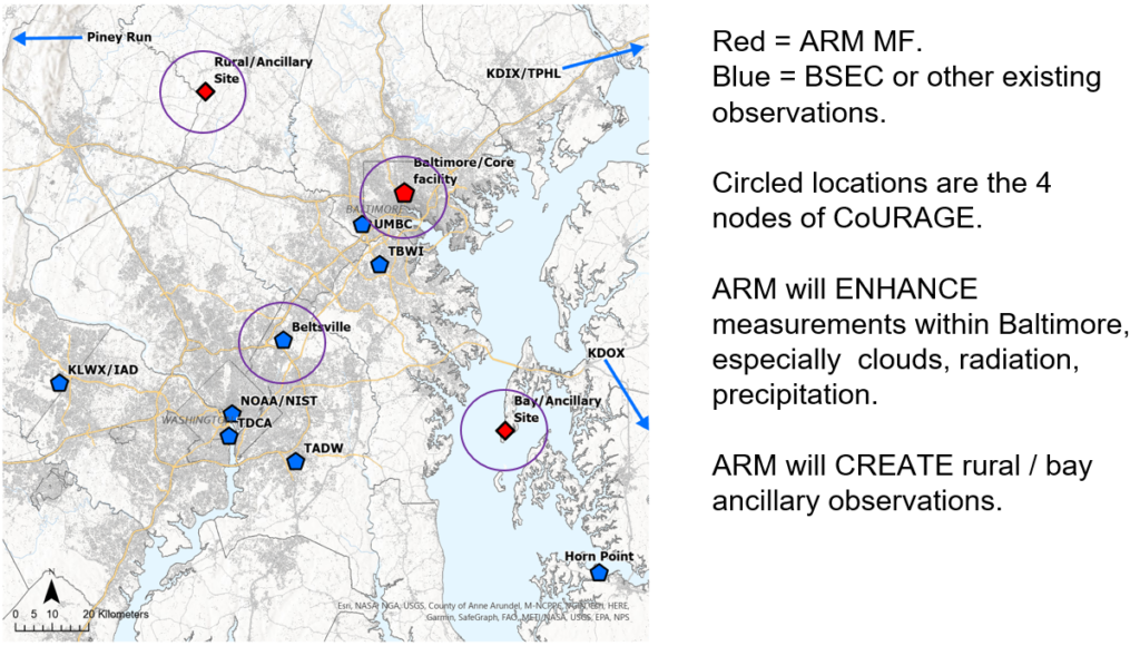
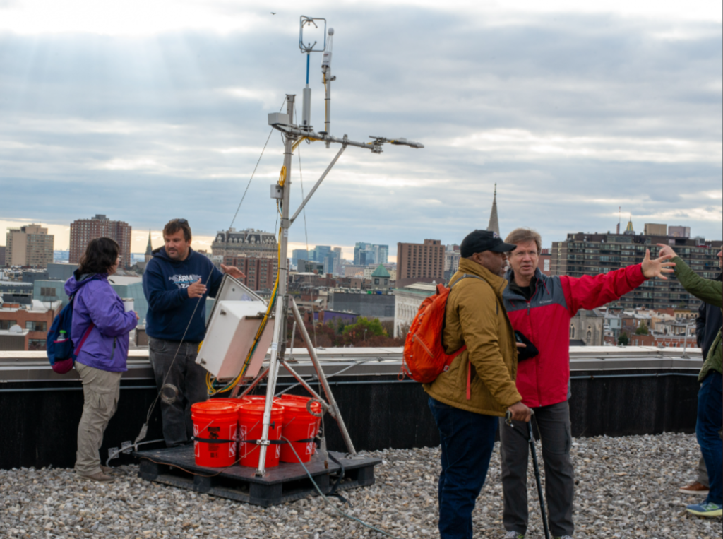
Activation of the DOE Coastal-Urban Rural Atmospheric Gradient Experiment (CoURAGE): The Department of Energy’s Atmospheric Radiation Measurement (ARM) Mobile Facility (AMF) consists of a suite of state-of-the art instruments designed to provide detailed measurements of the physical and chemical properties of the atmosphere. The data are used to support studies of cloud formation and rainfall processes, including extreme rain events, air pollution reactions and transport, greenhouse gas dynamics, and the drivers of local climate variability. CoURAGE is specifically focused on understanding the integrated coast-urban-rural system across Baltimore to provide deep scientific foundation for work on climate resilience and mitigation efforts. There will be coordinated aircraft and ground surveys held over the course of the year to complement the static CoURAGE measurement sites.

Buildings & Energy
Penn State members (Yizhi Yang, Rosina Adhikari, Yingli Lou, Wanda Zuo) published a new journal paper on building energy burden and carbon emission reduction:
Y. Yang, R. Adhikari, Y. Lou, J. O’Donnell, N. Hewitt, W. Zuo 2025. “Long-Term Impact of Electrification and Retrofits of the U.S Residential Building in Diverse Locations.” Building and Environment. 269. 112472. https://doi.org/10.1016/j.buildenv.2024.112472.
This research highlights a tradeoff between decarbonization and energy burden alleviation, showing that while energy efficiency building retrofit measures can reduce the energy burden, they only achieve one-quarter of the carbon emission reduction of electrification. Electrification may increase the energy burden for low income families in cold climate due to high capital cost and electricity cost.
In this quarter the Buildings & Energy team also advanced their analysis of household energy data provided by BG&E. There has been some delay due to legal considerations governing the use of data, but these hurdles were recently overcome and we anticipate significant progress in coming months.
Greenhouse Gases / Water & Water Quality
Analysis of long-term data collected by the Baltimore Ecosystem Study (BES) shows that riparian water tables have increased over the past 25 years with effects on biogeochemistry including decreases in nitrate and increases in phosphate levels in riparian groundwater. The change in water tables can be viewed as an increase in hydrologic “connectivity” driven by changes in best management practices. This work is published: Washington et al (2024): https://doi.org/10.1002/jeq2.20654
Work led by Groffman has focused on how changes in the terrestrial aquatic interface influence greenhouse gas fluxes (methane, nitrous oxide) in urban watersheds. Urban forests and grasslands have less methane uptake than rural forests. Urban riparian zones and green stormwater infrastructure features can be hotspots of methane production. Urban forests and riparian zones have higher nitrous oxide fluxes than rural (reference) forests and riparian zones. These results were presented in a poster at the Fall 2024 American Geophysical Union meeting; https://agu.confex.com/agu/agu24/meetingapp.cgi/Paper/1549620
Work led by high school teachers (funded by a National Science Foundation Research Experiences for Teachers grant to the Cary Institute) found there green stormwater infrastructure features had higher methane fluxes and lower denitrification potential than natural riparian zones.
Health
Trainee reports:
Bianca Smith, PhD candidate. Her recent work has included investigating the association between heat exposure and childhood asthma morbidity. The analysis includes high resolution temperature and humidity data from Baltimore City and pediatric asthma data from the Johns Hopkins Precision Medicine Center of Excellence. Recent analyses compared different definitions of heat exposure, including definitions of heat waves that have been used in prior research and in prior public health contexts. The findings suggest that heat exposure is associated with increased risk of childhood asthma exacerbation. The variability in the estimate of association related to the definition of heat exposure is an important findings that has methodologic implications for the field of climate and health research and also public health implications. For example, preliminary findings suggest that the definition of an extreme heat event that is used by the Baltimore City Health Department may be less sensitive for identifying risk for childhood asthma compared to alternative definitions that have been used in prior research. Next steps will include comparing high resolution temperature data to lower resolution data from central site monitors to quantify the value added of high resolution monitoring to elucidate health impacts.
Emily Scott, PhD Candidate in Biostatistics. Her recent work has included investigating the association between heat and asthma morbidity across the lifespan, including pediatric and adult data. Among the pediatric population, her analyses has included a comparison between Maryland and Florida. Her recent findings suggest that modeling of temperature deviation from expected rather than peak temperature may be more robust to bias in temporal trends in heat exposure. She has submitted an abstract to present her work at the Johns Hopkins Department of Medicine and Shiting School of Engineering Research Retreat.
Investigators from Penn State have obtained IRB approval to study the contribution of weather and weather changes on maternal morbidity. The data use agreement is pending and once approved, Penn State investigators will begin data analysis to address these hypotheses. Penn State has been meeting every other week as a team to go review and validate ASOS and MADIS environmental data and to integrate social determinants of health data. The Penn State team has submitted a data request for birth certificate records from the MD Department of Vital Statistics and their request is under review.
Vegetation & Soils
We are busy working on collections from the 2024 field season.
The JHU and USFS group (Sam Votzke, Kathy Szlavecz, Meghan Avolio, Ian Yesilonis and undergraduate interns) are exploring the data collected and doing lab work to process the soil and plant samples collected. So far we are finding:
- On vacant lots, soil properties differ between legacy yards and the site of the demolished home. Specifically, 1 M deep cores on the house footprint have higher gravel and sand content, and lower silt content. Depth of HAHT (Human Amended Human Transported) soil is also higher on the house footprint. These results were presented in a poster at the Fall 2024 American Geophysical Union meeting; https://agu.confex.com/agu/agu24/meetingapp.cgi/Paper/1726366
- Soil organic matter: Across land use types, the majority of SOM measurements ranged between 3-8%. For urban forest and park sites, all measurements ranged between 3-9%. For street sites, 33% of sites measured (7 sites out of 21 total) between 10-15% organic matter.
- Soil pH: Across land use types, the pH range measured was 3.00-7.00. Park and street sites had similar ranges between 3.50-7.00. Urban forest sites were the most acidic overall and had the smallest range, between 3.50-6.00. Nearly 50% of the street sites measured were between 6.00 and 7.00. 50% of the park sites measured were between 5.00 and 6.00. pH was measured over a 20 minute period and repeated, and an average taken of the two samples measurements.
- Soil compaction: Soil compaction was measured using a penetrometer, which was inserted into the soil 3 times per site until a reading of 300 psi, and the average taken of these 3 measurements. All sites ranged between 2cm and 30 cm of compaction. However, 30 cm was only measured at one urban forest site and the majority of measurements ranged between 2 and 14 cm.
- Although a wide range of soil measurements were taken for each variable, no significant difference emerged between land use types.
- Trees and photosynthetic curves: Overall no significant difference was found between land use types, but there were significant differences between tree species. Ailanthus altissima, or Tree of Heaven, had the highest photosynthetic rate of 6 broadleaf decidious species.
- Water infiltration (unsaturated flow) differs depending on land use, where vacant lot soils were the highest, forest the lowest, and park in the middle. These results were presented in a poster at the Fall 2024 American Geophysical Union meeting; https://agu.confex.com/agu/agu24/meetingapp.cgi/Paper/1744770
- Work led by high school teachers (funded by a National Science Foundation Research Experiences for Teachers grant to the Cary Institute) found there was higher lead in soils from lawns compared with street tree pits.
Data continues to be collected at the flux tower at Clifton Park (Ben Ahlswede) with a new deep pit being dug to track soil moisture, temperature and soil matric potential over time at three depths (Ian Yesilonis). To date we have found:
- The grasses are growing in the spring and early fall and going into dormancy during the middle of summer when it is the hottest.
The ELM model is being run at a much higher resolution to study processes over Baltimore (Dan Ricciuto). The Noah-MP model is beginning to be parameterized for Baltimore (Ben Ahlswede).
Finally, we are working on a publication exploring whether socio-economic factors impact net ecosystem exchange across the city (Dexter Locke, Nancy Sonti, Ken Davis, Jason Horne, Meghan Avolio). Data analyses are in the preliminary stages.
In the fall, we (Kathy Szlavecz, Ian Yesilonis, undergraduate students) continued community-requested soil sampling for heavy metal testing. We sampled a playground, churchyards and vacant lots in East Baltimore. Combined with the summer samples we analyzed a total of 44 samples. We plan to report the findings below back to the community and to the individual homeowners in January or February community meetings.
- Lead concentrations were exceeding EPA thresholds in 20% of the cases.
- In Howard Park, lead and zinc concentrations around homes were significantly higher than closer to the street.